
Mount Fuji from the North Foot Observatory 2
Forest and the direction of Mount Fuji from the mountain's northern foot
- Source
- Ministry of the Environment Biodiversity Center
- Format
- Official page · still preview
Written and edited by: JapanLiveNow
富士北麓からみた富士山2
This official Ministry of the Environment image looks toward Mount Fuji above the forest at the mountain's northern foot. For Fuji across the water, use a Lake Kawaguchiko shore camera instead. Check the image capture time, and use separate official sources for climbing access, volcanic information and road conditions.
Kofu · Conditions at the camera site may differ.
Choose this still for Mount Fuji rising beyond the forest on its northern foot. Check the capture time before treating the cloud in the image as current.
Official page · still preview. This is a still-image preview, not continuous video. Check the official page for its capture time and any video feed.
Clear visibility here does not establish conditions on trails or at the Fifth Station. Check current hiking, volcanic and road notices separately.
If the image has not changed, check its source timestamp or service notice.
Operator and source information ↗
Report an error or ended video for this camera · Our editorial standards
Mount Fuji from the North Foot Observatory 2 (富士北麓からみた富士山2) is an official still photo of Mount Fuji and the forest at the mountain's northern foot in Yamanashi (山梨県). Lake Kawaguchiko views show the mountain from the lakeshore. This camera shows it from close to the northern forest. A clear photo does not mean the weather is clear on the climbing trails or at the Fifth Station.
This is not live video. It is a still photo on the official page of the Ministry of the Environment's Internet Nature Research Institute, and it is updated about once every hour (every 3,600 seconds). Before you judge the clouds, look at the capture time, which is in Japan Standard Time (JST). To see the latest image, open the official page.
The Yamanashi Prefectural Fujisan World Heritage Center (山梨県立富士山世界遺産センター) is about 4.9 km away in a straight line. It explains why Mount Fuji became a World Heritage Site. The North Building covers the mountain's nature, and the South Building covers its cultural links with people. Entry to both buildings is free. The South Building closes on the fourth Tuesday of each month, or on the next day if that Tuesday is a public holiday.
Fees, hours and access for nearby places come from the official sources recorded in our attraction guides; confirm them on each venue’s official page before you go. Edited 2026-10-31.
| Camera | What it shows | Open source |
|---|---|---|
| Mount Fuji from the North Foot Observatory 2 | Forest and the direction of Mount Fuji from the mountain's northern foot | Official page · still preview ↗ |
| Mount Fuji from Kawaguchiko | Mount Fuji from the grounds of Kawaguchiko Lakeside Hotel | Official page · still preview ↗ |
| Oishi Park on Lake Kawaguchi | Lake Kawaguchi and the view toward Mount Fuji from Oishi Park | Official camera page ↗ |
The pin marks the camera facility or a documented reference point. Some cameras are on hotel roofs or broadcast buildings that visitors cannot enter. Check the entrance to the place you actually plan to visit.
The closest station by coordinates is Fujisan Station, 5.3 km from the camera reference point in a straight line. This is not a verified walking route or recommended access station. Check the visitor destination and its official access information.
Forest and the direction of Mount Fuji from the mountain's northern foot
Mount Fuji from the grounds of Kawaguchiko Lakeside Hotel
Lake Kawaguchi and the view toward Mount Fuji from Oishi Park
Mount Fuji from the Panoramic Ropeway's upper observatory
Lake Kawaguchi and Mount Fuji from Kogetsu on the northern shore
Lake Kawaguchi and Mount Fuji from THE KUKUNA on the eastern shore
Camera facility location · 35.44225, 138.76658
The map also shows rail lines serving Fujisan Station. The distance above is a straight line, not a walking time. Check the actual entrance and route below.
The closest station in a straight line may not be the easiest way in. The route also ends at the camera reference point, so change it to the place you actually plan to visit. Check buses, journey time and first or last trains in the route results.
Distances are straight lines between camera reference points, not actual journey distances or times.
 No on-site preview · check the official source
Yamanashi
富士急ハイランド FUJIYAMAタワー
The Fujikyu Group's official live camera looks toward Mount Fuji from FUJIYAMA Tower at Fuji-Q Highland. Check the official page to confirm the stream is currently available.
About 4.9 km · straight line
Fuji-Q Highland
Watch on YouTubeNo on-site preview · check the official sourceYamanashi
忍野 しのびの里
The official camera at Oshino Shinobi no Sato looks toward Mount Fuji. Check the mountain and sky before visiting Oshino Hakkai, and confirm stream availability on the source page.
About 4.9 km · straight line
Oshino Shinobi no Sato
Watch on YouTube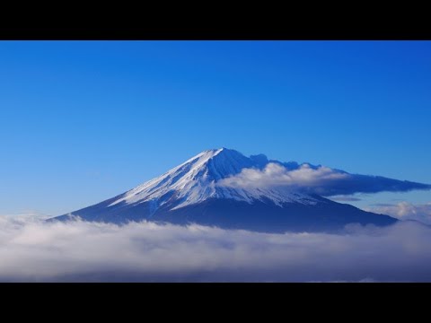 YouTube · Video thumbnail · check live status at source
Yamanashi
富士山五合目受付窓口付近(吉田ルート)
See the reception area at the Fifth Station General Management Center on Mount Fuji's Yoshida Route. Yamanashi Prefecture operates this seasonal camera during the climbing season; check the source for stream availability.
About 6.1 km · straight line
Yamanashi Prefecture
Watch on YouTubeExternal preview restricted · check the official sourceYamanashi
富士急行線河口湖駅前
UTY's official camera at Fuji Kanko Kaihatsu headquarters overlooks the area around Kawaguchiko Station and nearby tracks. The broadcaster may switch views for reporting or emergencies.
About 6.3 km · straight line
UTY Television Yamanashi
Watch on YouTubeNo on-site preview · check the official sourceYamanashi
忍野村 お宮橋からの富士山
See Mount Fuji and the Shinnasho River surroundings from Omiyabashi Bridge in Oshino. The village's official page provides the still image and its capture time.
About 6.4 km · straight line
Oshino Village
Open official cameraNo on-site preview · check the official sourceYamanashi
河口湖 富士山パノラマロープウェイ 展望台
The Mt. Fuji Panoramic Ropeway offers an official 4K live camera view from its upper observatory. Check the mountain outlook before a ride or walk on Mount Tenjo, and confirm stream availability on the official page.
About 6.9 km · straight line
Mt. Fuji Panoramic Ropeway
Watch on YouTube